Johann Bernard Fischer von Erlach (1656-1723) is known as one of the most prominent representatives of European Baroque. His architectural work had a significant impact on the identity of imperial Vienna. However, Fischer von Erlach is also well-known for the Entwurff einer historischen Architectur. First published in 1721, the Entwurff consists of five books containing plates and descriptions in German and French. The scholarly literature on the Entwurff offers two major interpretations. The first sees the Entwurff as a repertoire of architectural examples to be perused by amateurs, while the second sees it as a history of architecture, more appealing to antiquarians, and the first of its kind in its universal reach. Arguably, Fischer himself intended the Entwurff to be seen as the former, stating in the preface that he wanted to:
provide specimens of any sort of architecture to art amateurs, and new sources of inventions to those who are devoted to this activity, rather than instruct the savants. […] This is but a sketch; a show of different specimens of architecture. Nothing more should be seen in it.
The first book of the Entwurff, focusing on ‘some buildings of ancient Jewish, Egyptian, Syrian, Persian, and Greek architecture’, includes the Seven Wonders of the ancient world, the Temple of Solomon, and a few other monuments. The second book highlights Roman buildings, while the third book features ‘Arab,’ ‘Turkish,’ and ‘Modern Persian’ structures, as well as buildings and landscapes from China and Siam. Then the Entwurff presents the buildings designed by Fischer himself, before concluding with a collection of vases in the fifth book. The design and content of the Entwurff amply allowed for the ‘historical’ interpretation, which has dominated scholarly literature since the end of the nineteenth century. Recently, Monica Preti and Marco Folin gave new strength to the ‘collection’ perspective instead, emphasising the lack of coherence and improvised character of the Entwurff, linking it to historical atlases and ‘exotic geography’ rather than to antiquarian scholarship or art history.
In this article, I will try to uncover the potential for history embedded in the very looseness and fragility of the Entwurff as a repertoire of architectural specimens, by focusing on some of its most understudied components: the map of the Mediterranean and the ‘Persian’ plates included in the first book.
Fischer began working on the Entwurff around 1704. The National Library of Zagreb contains many of the preparatory drawings, which were engraved around 1712. A manuscript version of the work was then presented to Charles VI, the newly-crowned Habsburg emperor, as a gift. The title page attributed the ‘short descriptions in German and French’ to the Stockholm-born court antiquarian Carl Gustaf Heraeus (1671–1725), but there is much debate about his actual involvement in the project. However, the connection between architectural practices and antiquarian knowledge was common in European visualisation of antiquity: even the most imaginative reconstructions often required reference to written or material documents.
This connection was at play for Persia too. In particular, the ruins of Persepolis were regularly visited by European travellers since the early seventeenth century and had attracted the attention of learned milieus such as the Royal Society of London and the scholarly circle of the Amsterdam politician and polymath Nicolaas Witsen. Over the course of several decades, as qualitatively different visual descriptions accumulated in printed accounts, access to Persian antiquities was provided by a diverse range of interconnected printed materials, with or without the mediation of antiquarian milieus. Fischer’s attention to them can therefore be interpreted as participation to a widely diffused and even ‘fashionable’ trend, rather than as an exceptional fact.
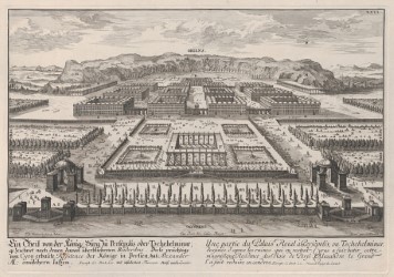
The high cultural status of Persian antiquities in early-eighteenth-century Europe may be the primary reason why Fischer included them in the first book of the Entwurff and in the ‘general chart meant to mark the position of each of the buildings contained’ therein (Fig. 1). At first glance, the Allgemeine Landcarte / Carte generale resembles a typical map of the Eastern Mediterranean, reprising a long-established format in the European cartographic tradition of the sixteenth and seventeenth centuries.
Figure 1 The Allgemeine Landkarte / Carte generale included in the first book of the Entwurff as early as 1712. Sammlung von Handschriften und alten Drucken, Österreichische Nationalbibliothek, Cod. 10791 HAN MAG, http://data.onb.ac.at/rec/AC13966906
Some specific features, however, stand out. The first is the variation on a conventional cartographic device, miniature city views enclosed in square framings and distributed along the map’s borders. Fischer used this device to display thumbnails of monuments. Each box is placed near the supposed original location of the monument, while the captions are given in the legend spread across the lower left corner of the map. The Landcarte thus allowed for a cartographic and miniaturised visualisation of the iconographic programme reproduced through the plates included in the 1712 manuscript version of the Entwurff.
Another striking feature of this map is its longitudinal span, extending to the Iranian plateau. Here, the easternmost thumbnail represents Cyrus’s royal palace, another one of Fischer’s designs. Cyrus was one of the few historical figures to play a pivotal role in both sacred and prophane history as Europeans understood it. Not only did he liberate the Jews from the Babylonian captivity, but he was also the good prince par excellence in Xenophon’s Cyropaedia, a centrepiece of specula principum literature well into the early modern era. While the inclusion of Persia in this ‘cultural geography’ of the ancient Mediterranean presented the viewer with an expansive depiction of art and architecture in antiquity, it may also have guided Fischer’s selection of a cartographic blueprint.
Preti and Folin have recently argued that Fischer repurposed the map of the Mediterranean included in the first volume of Chatelain’s Atlas historique, published in Amsterdam in 1705. While the resemblance between the two maps is striking, the framing of Fischer’s map may have been also indebted to European cartographic representations of the Ottoman empire. George Kunoth suggested that Fischer’s map derived from the Atlas nouveau published in 1692 by Guillaume Sanson and Hubert Jaillot. However, any map of the Ottoman empire could have served as a blueprint for the architect’s work, from the Hondius editions of Mercator’s maps to those of Joan Blaeu.
Thus, a cartographically trained eye may have recognized the underlying blueprint while glancing at Fischer’s map. While it is impossible to know for sure what the reaction was, we may wonder on the complex temporal, geographical, and cultural intersections evoked by this visual palimpsest. In fact, whether we see the Entwurff as a collection of loosely connected sights or as a ‘history of architecture,’ the content of the first book was part and parcel of a shared cultural legacy for European learned élites. The very role of the plates as ‘sources of invention’ allowed readers to establish connections between the past and the present by going through them. Furthermore, while the novelty of Fischer’s operation was the superimposition of an architectural subject over a map of the Eastern Mediterranean, this case of visual contamination was not unique. Chatelain himself was able to map the military expeditions of Alexander the Great onto the eastern portion of his map, just as Sanson had done for ‘sacred geography’.
Using a chart of the Ottoman empire to lay out before European eyes such a temporally-laden landscape from the heart of the Habsburg dominions may have been seen as an attempt to move a present drive to appropriation of space back into a foundational past. On the other hand, considering the appreciative character of the Entwurff towards Ottoman architecture, the use of the ‘Ottoman’ map for the Seven Wonders of the ancient world could be troubling, since it may remind the viewer that those lands were now the abode of a powerful polity whose eventual demise – even after the humiliating Treaty of Karlowitz (1699) – was all but certain. However, the framing of Fischer’s Landcarte is best seen as part of a constellation of different cartographical visualisations of history both sacred and prophane, centred on the Eastern Mediterranean. Arguably, such a context provided for historical interferences and contaminations more than for linear and clear-cut narratives.
This point is further illustrated by the two ‘ancient Persian’ plates in the first book of the Entwurff. In the manuscript from 1712, Fischer included a depiction of the royal palace of Cyrus that he had designed (Fig. 2), along with a large textual description which drew on evidence from Greek and Latin authors as well as eyewitness accounts from travellers in order to support the architectural reconstruction.
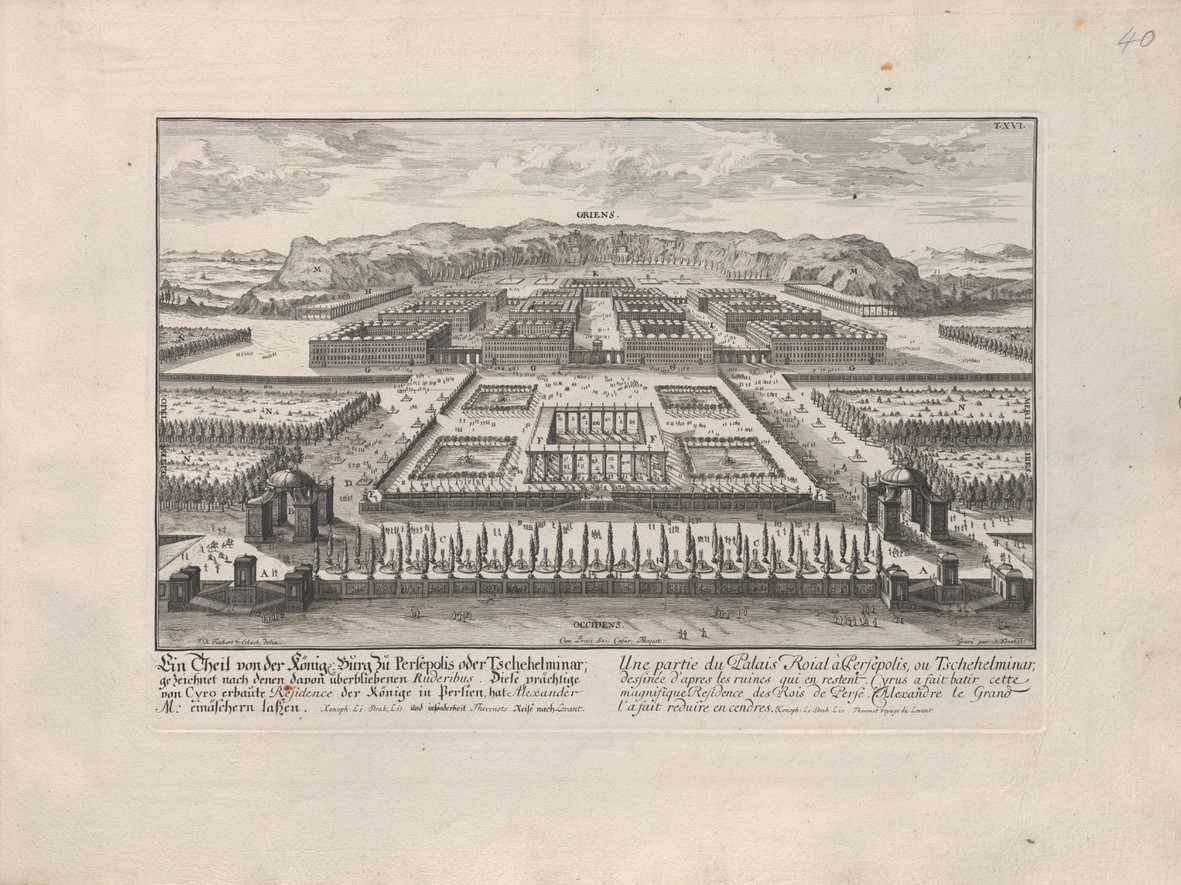
Figure 2: Ein Theil von der Könige Burg zu Persepolis oder Tschehelminar / Une partie du Palais Roial à Persepolis, ou Tschehelminar, plate XVI of the manuscript Entwurff from 1712. Sammlung von Handschriften und alten Drucken, Österreichische Nationalbibliothek, Cod. 10791 HAN MAG, http://data.onb.ac.at/rec/AC13966906
Likewise, Fischer did his best to incorporate architectural elements supported by travel reports in his Persepolitan phantasy. The architect, however, gave the complex a marked ‘orientalised’ appearance by shaping the roof of many of its building as clusters of onion-shaped domes. This did not necessarily entail a pejorative view, if we follow Kunoth’s hypothesis that the accounts of Persepolis had played a significant role in Fischer’s original projects for Schönbrunn castle. In fact, around 1712, Chehelmenār was viewed by Fischer as the royal palace of Cyrus. It may have seemed appropriate for Fischer to present the newly appointed emperor with a view of the marvellous palace of one of history’s most highly-regarded princes.
This beautiful plate was replaced with another in the first printed edition of the Entwurff, published in 1721. Instead of featuring Cyrus’s royal palace, the new plate depicted two rock-cut tombs (Fig. 3). While the dating of the preparatory drawing is uncertain, it is likely that this change occurred after 1712, since the engraving was directly derived from plates LXVII and LXVIII of Jean Chardin’s Voyages en Perse, published in Amsterdam in 1711.
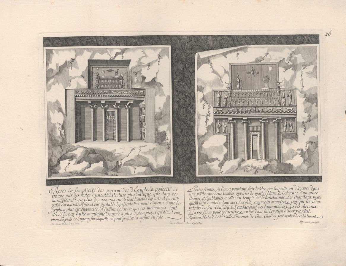
Figure 3: The new ‘Persepolitan’ plate in the printed Entwurff from 1721. Bildarchiv und Grafiksammlung, Österreichische Nationalbibliothek, 268697-C FID MAG, http://data.onb.ac.at/rec/AC06610081
What can we infer from this substitution? For one thing, it aligns with the historiographical narrative of antiquarianism as an intellectual force driven by empirical evidence. Fischer likely preferred to have a ‘real’ visualization of an ancient monument instead of a fanciful reconstruction, however laden with aesthetic and political values the latter may have been. However, it also reinforces the idea of accumulated knowledge as a resistant force, since the Landcarte still reproduced the plate for Cyrus’s palace in the thumbnails. This was most likely because it was not practical to redesign and re-engrave the plate for such a small detail. At the same time, the large explanatory text had been removed and the new caption of the plate implemented two interpretive shifts.
After the simplicity of the pyramids of Egypt, posterity does not find remains of a more ancient architecture than in these mausoleums. For more than 3000 years they have born witness to the arts and to the pagan cult of the ancient Persians. Their true representation dispenses us from a more detailed description. […] [the letter B in the picture on the right indicates] columns of a strange order, and similar to those of the temple of Tschehelminar. Figueroa, Herbert, de la Valle, Thevenot, the chev. Chardin mention this building.
The first interpretive shift was chronological. In the 1712 version, the reader was left assuming that the complex dated to five to six centuries before Christ was born, as Persepolis was associated with Cyrus. However, the 3000 years of the 1721 version pushed the construction of the complex much further back in time, positioning it right after the pyramids and before the Temple of Solomon (whose foundation was determined by Erlach around 1000 years before Christ). The foundational role played by the Temple of Solomon in the development of architecture was confirmed by the descriptive text attached to the corresponding plates. However, the ancient Persian art to which the tombs bore witness could now claim a greater antiquity than the Temple, thus constituting an alternative pole of achievement which deserved a place in the Entwurff while not playing an explicit role in the ancient history of architecture.
The other interpretive shift is functional. While the caption of the 1712 plate explicitly defined Chehelmenār as the ruins of a royal palace, in 1721 the same site is connected to a temple and, moreover, to the pagan cult of the ancient Persians. The combination of the religious function of the complex and the high chronology attributed to the tombs points to the specific interpretation provided by Chardin. The traveller had argued for Chehelmenār to be a 3000-years-old temple, by drawing on the Persian historiographical and poetical tradition that viewed Chehelmenār as the ancient abode of the first mythical kings of Persia, the Pishdadians. His description of the ruins overflows with references to King Jamshid and to the common Persian definition of antiquities as bot-khané, ‘house of idols,’ a starkly religious definition. We may argue that the drive to empiricism witnessed by the substitution of the plates also allowed for and even legitimised the entry in the Entwurff of a bit of ‘alien wisdom,’ as Arnaldo Momigliano would have called it.
In conclusion, Fischer’s map of the ancient Mediterranean and his ‘Persepolitan’ plates reveal the instability and flexibility of the historical outlines of artistic development – and then of the very notion of Antiquity – that could be derived from collections of architectural examples. Before the Greek-centric representations of art history became dominant in the late eighteenth century, there was a period of experimentation considering which we may apply the concept of ‘inclusive Eurocentrism’ – proposed by Jürgen Osterhammel for eighteenth-century culture at large – to the domain of art history. The mobile and tentative nature of such experimentations, as seen in the Entwurff, is even more demonstrated by the abrupt shift in the ‘Persepolitan’ plates. While this allowed for a broader perspective and the percolation of ‘alien wisdom,’ it also meant inherent fragility. Eventually, these extra-European connections would break down and be rearranged in more hierarchical patterns, ultimately failing to translate into an inclusive history of art and architecture.
Primary sources
Jean Chardin, Voyages en Perse et autres lieux de l’Orient, ed. Louis-Mathieu Langlès, 10 vols. (Paris: Lenormant, 1811)
Johann Bernard Fischer von Erlach, Entwurff Einer Historischen Architectur, In Abbildung unterschiedener berühmten Gebäude, Österreichische Nationalbibliothek, Cod. 10791 HAN MAG, http://data.onb.ac.at/dtl/3312795
Johann Bernard Fischer von Erlach, Entwurff Einer Historischen Architectur, In Abbildung unterschiedener berühmten Gebäude (Wien: s.n., 1721), Österreichische Nationalbibliothek, 268697-C FID MAG, http://data.onb.ac.at/dtl/3325628
Bibliography
Sussan Babaie, ‘Architectural ‘Worlding’: Fischer von Erlach and the Eighteenth-Century Fabrication of a History of Architecture,’ Journal18 12 (Fall 2021), https://www.journal18.org/5993
Matteo Burioni, ‘Die Perspektivität der Himmlischen Stadt. Johann Bernhard Fischer von Erlachs Darstellung außereuropäischer Kultbauten und die Tradition der Reiseberichte,’ in Götterbilder und Götzendiener in der Früher Neuzeit. Europas Blick auf fremde Religionen, ed. Maria Effinger et al. (Heidelberg: Universitätsverlag Winter), 107–115.
Marco Folin and Monica Preti, Da Gerusalemme a Pechino, da Roma a Vienna. Sul Saggio di Architettura storica di J. B. Fischer von Erlach (Modena: Franco Cosimo Panini, 2019)
Thomas DaCosta Kaufmann, ‘Eurocentrism and Art History? Universal History and the Historiography of the Arts before Winckelmann,’ in Memory & Oblivion. Proceedings of the XXIX International Congress of the History of Art, Amsterdam, 1-7 settembre 1996, eds. Wessel Reinink and Jeroen Stumpel (Dordrecht: Springer Science / Business Media, 1999), 35–43
Thomas DaCosta Kaufmann, ‘Antiquarianism, the History of Objects, and the History of Art before Winckelmann,’ Journal of the History of Ideas 62, no. 3 (2001): 523–541
George Kunoth, Die Historische Architektur Fischers von Erlach (Düsseldorf: Verlag L. Schwann, 1956)
Jürgen Osterhammel, Unfabling the East. The Enlightenment’s Encounter with Asia (Princeton and Oxford: Princeton University Press, 2018)
Hans Sedlmayr, Johann Bernhard Fischer von Erlach architetto, ed. Giovanna Curcio (Wien / München: Herold, 1956; it. transl. Milan: Curcio, 1996)
Biography
Emanuele Giusti specializes in the history of historiography and the intellectual history of orientalism during the long eighteenth century, focusing particularly on the relationship between Europe and Iran. He co-edited the collective volume Rereading Travellers to the East. Shaping Identities and Nation-Building in Post-Unification Italy (2021) and is currently working on his first monograph, which explores the reception of Iranian monuments in European historiography of the eighteenth century.
